Status on 3 November 2026: the Cares Trail is open along its full length. On 2 November the Picos de Europa National Park confirmed that the traverse can be walked end to end between Poncebos and Caín, and in the opposite direction too, after a metal walkway was installed at the point where the path surface had collapsed.
The condition of a mountain path changes from one day to the next. Before setting off, confirm the day's status on the National Park website or ask us on WhatsApp: we are 6 km from Poncebos and we check daily.
If you landed here looking for whether the Cares is open, the short answer is yes. And if you had been following October's closure, this is the page we promised to update: there is news, and it is good.
What has changed since October
On 16 October the National Park closed the full traverse. The reason was maintenance work on two bridges — Bolín, about 8 kilometres from Poncebos, and Rebecos, about 3 from Caín — and above all the deterioration of a concrete platform that had opened a hole in the path.
The repair consisted of installing a metal walkway at that point, next to the Rebecos bridge. The route reopened on Friday 30 October, after 16 days closed, and on 2 November the Park management confirmed that the whole route is available again from end to end.
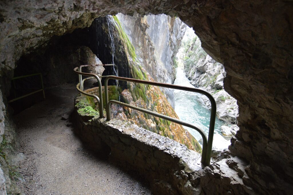
So do not be surprised to cross a new structure that does not appear in older photographs: it is part of the continuous maintenance of a path carved into the wall of the gorge almost a century ago to service the Cares canal. The Cares was closed completely between 2011 and July 2012 after a rockfall, and came back with the cantilevered walkway that is now one of its most photographed stretches. Works on this path are part of its history.
The rules the Park restated when it reopened
These are not our suggestions: they are the conditions the Park management put front and centre when announcing the reopening.
- Dogs: not allowed off the lead or on an extendable lead. A fixed lead may not exceed 1.20 metres.
- Bicycles: cycling on the path is prohibited. This was already in the trail's official description and still stands.
- Signage: it must be respected. If a section is marked off, you do not pass.
- No lateral protection: much of the route runs alongside a sheer drop, at considerable height, with no railing. It demands constant attention, especially with children.
- Falling rocks: a real risk along the whole route, from natural causes and from livestock grazing above the path. It increases with rain and wind, and in the days that follow.
The route's real numbers
There is a common confusion here worth clearing up, because it affects how you plan the day.
The official trail, PR-PNPE 3
In the National Park's own description, PR-PNPE 3 runs from Posada de Valdéon (León) to Poncebos (Asturias): 21 kilometres, 899 metres of descent and 160 of ascent, with an estimated time of between 3 h 20 min and 5 h 30 min. Medium difficulty: the path is straightforward, but long.
The stretch almost everyone calls "the Cares"
That is Poncebos to Caín: around 11 kilometres each way, some 22 if you walk out and back, with the climbing concentrated in the initial ascent from Poncebos. Allow 6 to 7 hours for the full out-and-back, unhurried and stopping to look.
The Park itself recommends that, if you are not in training, you walk only part of it and plan your return accordingly. That is a perfectly sensible decision: the most spectacular sections are in the middle, but the initial climb and the first views into the gorge justify the outing on their own.
Walking it from Poncebos in November
Starting from the Asturian side has one advantage: you get the climb over with at the beginning, while you are fresh, and come back downhill. The drawback is the Poncebos car park, which fills up early even outside high season; private vehicle access is restricted at certain times of year, with the Ovar car park as the alternative and a shuttle from there.
Three things that make the difference at this time of year:
- Set off early. In November it gets light late and dark early, so the window of daylight is narrow. Staying nearby lets you be at Poncebos first thing without an impossible start. Carry a head torch just in case.
- Enough water. There is no drinking water on the route. That comes from the official trail description, and it is the most repeated mistake on the Cares.
- Mountain boots. The path has loose stone. Street trainers are the number one cause of twisted ankles here.
What is good about November: far fewer people, low golden light reaching into the gorge, a strong river and hillsides in full colour. What to watch: overnight frosts leave the shaded sections slippery, and rain or wind increases the risk of rockfall. If the forecast is poor, it is not a Cares day.
If you are heading into the mountains at this time of year, it is worth reading our autumn safety notes and how to read the snow line first.
Getting here without a car: there is more bus than before
Since 3 November 2026 public transport in eastern Asturias has been reinforced, which makes reaching us without a vehicle considerably easier. The Cangas de Onís–Oviedo corridor now runs 16 daily connections Monday to Friday, with three new express services, and five services on the Arenas de Cabrales–Cangas de Onís line (leaving Arenas at 6:24, 7:30, 8:25, 12:30 and 17:35) connect at Cangas with the bus to Oviedo.
From Arenas to Poncebos there is a seasonal shuttle, stopping at the Ovar car park, Poncebos and Tielve. Timetables change through the year, so ask us before you travel and we will tell you how the service stands on your dates.
If the weather does not cooperate
The Cares is a long, exposed route. If the forecast turns, these alternatives work just as well — some of them better in autumn:
- The Foces del Casaño. The same landscape of rock and water on a short, level path, with no exposure and no climbing. The best option with children.
- Bulnes by funicular. It leaves from Poncebos itself, so it fits into the same morning and does not depend on the state of the path.
- The rest of the walks from Cabrales, including the climb to the foot of the Naranjo de Bulnes.
One note if you plan to drive the mountain roads of the valley: the road to Sotres is covered by the regional Winter Road Plan, in force until 30 April, and this year it has new digital panels showing road surface temperature in real time. Worth checking before you head up.
From El Ardinal
We are in Arenas de Cabrales, 6 kilometres from Poncebos: about 12 minutes by car. Which means we can tell you how the trail stands the day before you arrive, without you having to track news from home. Message us on WhatsApp from the contact page and we will confirm it.
If you want the full background to the route — history, distances, water, when to go — it is all in the Cares Route step by step. And if you are still choosing where to stay, where to stay for the Cares Trail explains which apartment suits your group.
Sources
- Picos de Europa National Park, official description of trail PR-PNPE 3.
- El Fielato, 2 November 2026.
- León 24 Horas, 30 October 2026.
- El Fielato, reinforced public transport in eastern Asturias, 2 November 2026.
- El Fielato, Winter Road Plan and signage at Sotres, 2 November 2026.